Leadership in Energy and Environmental Design (LEED) is a certification program that encourages the adoption of sustainable design, construction and operation practices as applied to buildings and communities. Think of LEED as a way of promoting a green approach to community development.
From a civil engineering perspective, LEED for Neighborhood Development (LEED ND) is an opportunity to bring together engineering design and GIS analysis methods in order to meet a set of documented requirements for achieving LEED certification. For example, the Smart Location and Linkage category encourages brownfield developments to reduce urban sprawl. Maximum credit can be attained if the project is located in a previously developed infill site that is also in a high-density area. In this case, high-density is a function of the number of street intersections within a half-mile of the project boundary.
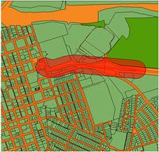
 To determine how well a project complies with these criteria, we can apply an Engineering GIS approach that leverages both CAD and GIS data. First, rather than using an import/export method to bring together the required data, FDO data providers are used to connect the GIS-based parcel and street centerline data to the CAD-based site design. Next, a geospatial buffer is created at a distance of a half-mile from the site boundary. The buffer is used to determine proximity and involves generating a polygon at a specified distance from the proposed site boundary. Finally, in this simplified example, a geographic query is used to determine the number of intersections within the buffer and this number is compared to the LEED criteria.
Some of the benefits of this approach include the following:
From a civil engineering perspective, LEED for Neighborhood Development (LEED ND) is an opportunity to bring together engineering design and GIS analysis methods in order to meet a set of documented requirements for achieving LEED certification. For example, the Smart Location and Linkage category encourages brownfield developments to reduce urban sprawl. Maximum credit can be attained if the project is located in a previously developed infill site that is also in a high-density area. In this case, high-density is a function of the number of street intersections within a half-mile of the project boundary.
 To determine how well a project complies with these criteria, we can apply an Engineering GIS approach that leverages both CAD and GIS data. First, rather than using an import/export method to bring together the required data, FDO data providers are used to connect the GIS-based parcel and street centerline data to the CAD-based site design. Next, a geospatial buffer is created at a distance of a half-mile from the site boundary. The buffer is used to determine proximity and involves generating a polygon at a specified distance from the proposed site boundary. Finally, in this simplified example, a geographic query is used to determine the number of intersections within the buffer and this number is compared to the LEED criteria.
Some of the benefits of this approach include the following:
- Data conversion and data redundancy can be avoided as a result of using FDO data providers to connect to the data directly rather than relying on an import/export process.
- Efficiency is improved as a result of applying an approach that embraces CAD tools for site design and geospatial tools for analysis all in one software platform.
- Better designs are possible because more design alternatives can be evaluated against LEED criteria.
Check out the video to see the process in action using AutoCAD Map 3D.


