
With over 150 sessions either highlighting or referencing BIM at Autodesk University (AU2010), BIM was certainly a popular topic. And now, you probably know that BIM is about using model based designs for better planning, faster visualization and stronger management. But if you’re looking for a brief explanation of what BIM is so that you can share what you’ve learned with your colleagues in a way that doesn’t cause their eyes to glaze over, check out the these two short videos.
This first video explores an entire project lifecycle and shows how BIM solutions can help make our cities more sustainable.
This second video emphasizes the role of information modeling in planning, designing, visualizing and managing municipal and utility infrastructure.
Wednesday, December 15, 2010
Tuesday, December 14, 2010
CAD/GIS Integration Problems Persist
 Whether it’s CAD or GIS, we all use a variety of tools to get the job done. One would think though that after more than 20 years, the task of integrating CAD and GIS data would no longer be a problem.
Imagine my surprise then when both of my Unconference Sessions at Autodesk University (AU2010) were filled to capacity.
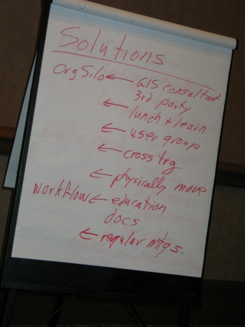
Each session began by exposing the magnitude of the CAD/GIS integration problem – a billion dollar problem that impacts engineers, contractors and suppliers throughout the planning, design and construction phases. However, these impacts pale in comparison to the many billions lost due to a lack of interoperability by the owner/operators during operation and maintenance phases (NIST).
 Participants were then divided into small groups to discuss their own CAD/GIS integration problems. The results were interesting. Technology it seems was not the main point of discussion. In fact, organizational influences, data ownership, lack of understanding, workflow and standards were the primary factors contributing to an organization’s lack of data integration.
Next, participants were asked to come up with a list of possible solutions. Again, rather than “fix the technology”, discussions centered around solving data related issues and increasing communication, collaboration and education on the CAD/GIS integration topic.

The session concluded by participants sharing their plan-of-action for tackling the issues exposed. In fact, when I asked participants, "Who is committed to tackling the CAD/GIS integration problem within their own organizations?", the vast majority raised their hands in a resounding yes!
If you were one of my session participants or are in the process of tackling your own CAD/GIS integration issues, please share your experiences by sending me a note or including a comment. I would love to hear about your progress.
For more session highlights, please check out Spatial Sustain and Matt Ball's blog on this topic.
Thursday, November 25, 2010
CAD/GIS Integration and Autodesk LandXplorer at AU2010

Are you struggling with CAD/GIS data integration? Well, if enrollments for my two AU2010 workshops (see blog) on this topic are any indication, it seems that you’re not alone. Data integration is a hot topic!
In fact, when you throw BIM and large-scale city and infrastructure models into the mix, the data integration issues can become overwhelming – especially if you don’t have the right plan or the right tools.
For example, Dan Campbell of the City of Vancouver is delivering a session (CV220-3P) entitled “Claiming New Territory with Autodesk LandXplorer”. I’ve seen Dan Campbell present numerous times. His sessions are always informative, entertaining and filled with lots of eye-candy.
You also don’t want to miss the hands-on lab (CV234-27) being led by Lynda Sharkey of Autodesk. Her lab is an introduction to Autodesk LandXplorer. Oh and be sure to check out the hilarious promo video for her class.
In fact, when you throw BIM and large-scale city and infrastructure models into the mix, the data integration issues can become overwhelming – especially if you don’t have the right plan or the right tools.
- How do you get the big picture when you need to aggregate CAD and GIS data, wireframes and building models, surfaces and aerial photos?
- How do you analyze and visualize this data in 3D quickly and efficiently?
For example, Dan Campbell of the City of Vancouver is delivering a session (CV220-3P) entitled “Claiming New Territory with Autodesk LandXplorer”. I’ve seen Dan Campbell present numerous times. His sessions are always informative, entertaining and filled with lots of eye-candy.
You also don’t want to miss the hands-on lab (CV234-27) being led by Lynda Sharkey of Autodesk. Her lab is an introduction to Autodesk LandXplorer. Oh and be sure to check out the hilarious promo video for her class.
Thursday, November 18, 2010
CAD and GIS Integration Workshop at AU2010
If CAD and GIS data integration issues continue to plague your organization, if you’re frustrated by working with unstructured CAD files, if you’re perplexed by rigid GIS data models, if you’re looking for easy ways to add CAD data to your GIS databases, or if you're bewildered by the many obstacles to CAD/GIS integration then my CAD and GIS integration workshop may be for you.
This year, at Autodesk University (AU2010), I am delighted to be facilitating two Unconference Sessions entitled, “The Billion Dollar Opportunity: A Workshop on CAD/GIS Integration”. These workshops are aimed at engineers, surveyors, architects, CAD and GIS professionals, and anyone interested in the CAD/GIS integration issue. Anticipated discussion topics will include:
But don’t wait; I fully expect the second session to fill too.
This year, at Autodesk University (AU2010), I am delighted to be facilitating two Unconference Sessions entitled, “The Billion Dollar Opportunity: A Workshop on CAD/GIS Integration”. These workshops are aimed at engineers, surveyors, architects, CAD and GIS professionals, and anyone interested in the CAD/GIS integration issue. Anticipated discussion topics will include:
- Drivers for CAD/GIS integration
- CAD/GIS integration scenarios
- Approaches for addressing CAD/GIS integration issues
But don’t wait; I fully expect the second session to fill too.
See you at AU!
Monday, November 15, 2010
A Cultural Shift in the GIS Industry
 In honor of GIS Day 2010, my colleagues Neal Niemiec, Pete Southwood and I have created an on-demand webcast that highlights Building Information Modeling (BIM) and its impact on the geospatial community.
If you’ve never heard of BIM, you’re not alone. Until recently, BIM has been the domain of architects and building owners. However, the application of BIM has expanded. BIM is now being embraced by municipalities, utilities, transportation departments, campuses and others with an interest in infrastructure; it’s not just about buildings anymore.
A Cultural Shift
BIM is creating a cultural shift in the GIS industry. Geospatial professionals know the power of GIS but many have little knowledge or experience with BIM. Increasingly, geospatial professionals are being asked to integrate BIM models with their GIS data. The task is often a struggle as they attempt to combine the data without losing valuable information. As a result, workflow suffers which compromises efficiency, affects decision making, and impacts data accuracy and currency.
An improved understanding of BIM can help overcome these challenges and ensure that BIM models and geospatial data are integrated in a manner that respects both design and GIS requirements.
If CAD and GIS are the Tools, BIM is the Toolbox
BIM is an integrated process that lets you explore a project’s physical and functional characteristics digitally, before it’s built. Again, BIM is not just about buildings; it’s information modeling for the built environment. As such, BIM encompasses CAD and GIS disciplines by combining model-based design with information and analysis.
BIM is multidisciplinary. It combines the complexity of both built and natural environments. It applies to municipal, transportation, utilities, as well as, campus style environments such as education, health care and airport facilities.
Access this on-demand webcast:
- Learn what BIM is and why it’s of importance to the geospatial professional.
- Discover how BIM helps improve CAD/GIS data integration workflows.
- See how intelligent model-based design helps promote “GIS Ready” data.
- Learn how BIM streamlines analysis, visualization and the ability to accurately predict performance, appearance and cost.
- Discover how BIM improves sharing of digital design information, geospatial data, infrastructure models and other documentation among staff and project stakeholders.
- Learn how BIM helps extend your GIS asset information into the design/build process to better coordinate with architects, engineers, contractors and others.
- Learn how to leverage BIM throughout construction, operation and maintenance.
- Discover how BIM helps you deliver projects faster, more economically and with reduced environmental impact.
- Learn how BIM reduces risk through a better understanding of a project’s physical, social and economic impact before breaking ground.
Follow this link to access the on-demand webcast and learn more about BIM for the geospatial professional:
Tuesday, November 9, 2010
Geospatial Sessions at AU2010
 I’ve been looking forward to Autodesk University (AU2010) for a whole year. The event is being held November 30 – December 2, 2010 and that’s only a few short weeks away. My excitement is definitely building. With 600 topics and 400 speakers to choose from and only 3 days to take it all in, I always find it a challenge deciding on which sessions to attend. Usually, I choose topics with a geospatial slant and this year is no exception. Check out the list I’ve compiled below of great geospatial sessions being offered at Autodesk University this year. These sessions offer a wonderful mix of tips, processes, strategies and new ideas for working with design and geospatial data. The topics are varied and cover planning, design, construction and maintenance using AutoCAD Map 3D, Autodesk MapGuide Enterprise, AutoCAD Civil 3D, Autodesk LandXplorer, Autodesk Topobase and more.
UT220-2: A Metadata to Remember: The Importance of Metadata Management for Infrastructure Utility Companies
Speaker: Anthony Neal, Senior Consultant, Autodesk
UT220-1: Sewer Master Planning with AutoCAD® Map 3D and Autodesk® Storm and Sanitary Analysis Extension
UT220-1: Sewer Master Planning with AutoCAD® Map 3D and Autodesk® Storm and Sanitary Analysis Extension
Speaker: Dan Leighton, Principal Consultant, DL Consulting
UT223-1U: Autodesk Solutions Add Valuable Situational Awareness for Utility Operations
UT223-1U: Autodesk Solutions Add Valuable Situational Awareness for Utility Operations
Speaker: Doug Laslo, Utility Industry Customer Success Manager, Autodesk
UT234-1: Solving Spatial Problems in a CAD-Driven GIS for Telephone Companies
UT234-1: Solving Spatial Problems in a CAD-Driven GIS for Telephone Companies
Speaker: Tim Jones, GIS Supervisor, Ponderosa Telephone
CV319-2: Air Force Civil Engineering's Decision to Use AutoCAD® Map for Its GIS Solution
CV319-2: Air Force Civil Engineering's Decision to Use AutoCAD® Map for Its GIS Solution
Speaker: Nathan Jaworski, Engineering Contingency Instructor, Red Horse
UT319-2: Optimizing Water/Wastewater Utility Drafting Workflows Using AutoCAD® Map 3D & Autodesk® MapGuide
UT319-2: Optimizing Water/Wastewater Utility Drafting Workflows Using AutoCAD® Map 3D & Autodesk® MapGuide
Speaker: Sean Dingman, Project Manager, Websoft Developers Inc
GS327-1: Spatial Databases with AutoCAD®, AutoCAD Map 3D, and Autodesk® MapGuide®
GS327-1: Spatial Databases with AutoCAD®, AutoCAD Map 3D, and Autodesk® MapGuide®
Speaker: Gordon Luckett, GIS Consultant, Arrow Geomatics Inc.
UT330-1: AutoCAD® Civil 3D® GIS: Migrating Pipe Network Data for Infrastructure Projects
UT330-1: AutoCAD® Civil 3D® GIS: Migrating Pipe Network Data for Infrastructure Projects
Speaker: Brian Lopez, EMEA Channel Services Program Manager, Autodesk
GS330-1: VanMap, Autodesk® MapGuide® Enterprise, and the 2010 Winter Olympics: A Host City Tale
GS330-1: VanMap, Autodesk® MapGuide® Enterprise, and the 2010 Winter Olympics: A Host City Tale
Speaker: Jonathan Mark, GIS and Topobase Support Manager, City of Vancouver
UT333-2: MidCoast Water: A Case Study on Implementing Autodesk® Topobase™ Client and Web
UT333-2: MidCoast Water: A Case Study on Implementing Autodesk® Topobase™ Client and Web
Speaker: Daniel Watson, ANZ Consulting Practice Lead, Autodesk ANZ
GS416-1: Moving to SQL Spatial: The Whole Nine Yards at Grand Forks
GS416-1: Moving to SQL Spatial: The Whole Nine Yards at Grand Forks
Speaker: Adam Jonasson, GIS Coordinator, City of Grand Forks
UT416-1: Water Companies Integrate CAD and GIS with AutoCAD® Map 3D
UT416-1: Water Companies Integrate CAD and GIS with AutoCAD® Map 3D
Speaker: Anja de Clercq, CAD Coordinator, VMW
GS422-1: Thousands of Raster Files in MapGuide: How Do I Make It Work?
GS422-1: Thousands of Raster Files in MapGuide: How Do I Make It Work?
Speaker: Jeremy Robson, Technical Architect, Autodesk
UT430-1: Integrating Autodesk® Topobase™ with Outage Management at the Kansas City Board of Public Utilities
Speaker: Matthew Kreig, Supervisor of Mapping & Drafting. Kansas City Board of Public Utilities
UT220-3U: Migrating to Autodesk® Topobase™ Electric: A Real World Experience
UT220-3U: Migrating to Autodesk® Topobase™ Electric: A Real World Experience
Speaker: Andy Morsell, Consultant, Autodesk, Inc.
UT223-2: Autodesk® Topobase™ Integration Blueprints
UT223-2: Autodesk® Topobase™ Integration Blueprints
Speaker: Pat Byrne, Subject Matter Expert – Utilities, Autodesk
UT231-2: Leveraging Geospatial Solutions for Maximum Benefit at Electric Utilities
UT231-2: Leveraging Geospatial Solutions for Maximum Benefit at Electric Utilities
Speaker: Allen Beaudette, Electrical Engineer, GL Noble Denton
CP234-1: Autodesk® MapGuide® as a Services Platform: Integrating with Other Applications
CP234-1: Autodesk® MapGuide® as a Services Platform: Integrating with Other Applications
Speaker: Giulio Pagan, Senior Consultant, Autodesk
CV319-3U: The Billion Dollar Opportunity: A Workshop on CAD/GIS Integration
CV319-3U: The Billion Dollar Opportunity: A Workshop on CAD/GIS Integration
Speaker: Michael Schlosser, Geospatial Subject Matter Expert. Autodesk
UT330-2: The Utility Plan-Design-Manage Workflow: A Global Tour of Industry Trends, Projects, and Innovation
UT330-2: The Utility Plan-Design-Manage Workflow: A Global Tour of Industry Trends, Projects, and Innovation
Speaker: Alan Saunders, Sr. Industry Manager, Autodesk
UT422-2: From AutoCAD® Map 3D to Autodesk® Topobase™ and Autodesk Topobase Web for Gas Utilities
UT422-2: From AutoCAD® Map 3D to Autodesk® Topobase™ and Autodesk Topobase Web for Gas Utilities
Speaker: Deeter Smith, GIS Administrator, Okaloosa Gas District
CV223-4: Using Autodesk® Storm and Sanitary Analysis on Large Stormwater Projects
CV223-4: Using Autodesk® Storm and Sanitary Analysis on Large Stormwater Projects
Speaker: Tim Olson, Water Reousrces Design Engineer, Bolton & Menk, Inc.
CV228-1: Autodesk® Topobase™ at the London 2012 Olympics: Managing the Transport Infrastructure
CV228-1: Autodesk® Topobase™ at the London 2012 Olympics: Managing the Transport Infrastructure
Speaker: Mike Chatterton, Information Knowledge Manager, KBR / Olympic Delivery Authority
UT228-1: Follow the Lines: Best Practices for Utility Projects at the City of Chur, Switzerland
UT228-1: Follow the Lines: Best Practices for Utility Projects at the City of Chur, Switzerland
Speaker: Daniel von Kaenel, Delivery Manager, Autodesk
UT330-3U: Process and Information Flow within the Utility Asset Management Life Cycle
UT330-3U: Process and Information Flow within the Utility Asset Management Life Cycle
Speaker: Kevin Miller, Utility Industry SME, Autodesk
CV416-2: AutoCAD® Civil 3D® and Infrastructure Modeling Solutions: Practically
CV416-2: AutoCAD® Civil 3D® and Infrastructure Modeling Solutions: Practically
Speaker: Neil Brooker, Technical Sales Manager, Autodesk
UT419-2U: Risk Management for Utility Industry Projects: The Key to Success?
UT419-2U: Risk Management for Utility Industry Projects: The Key to Success?
Speaker: Shashi Verma, Project Manager, Autodesk
UT422-1: Streamlining the Design through Asset Management Workflow at Anchorage Municipal Light & Power
UT422-1: Streamlining the Design through Asset Management Workflow at Anchorage Municipal Light & Power
Speaker: Chris Nailer, Technical Consulting Manager, Autodesk
UT433-1: Integrating Autodesk® Topobase™ with Infor™ Hansen Asset Management
UT433-1: Integrating Autodesk® Topobase™ with Infor™ Hansen Asset Management
Speaker: Joe Chandler, Technical Consulting Manager, Autodesk
CV220-3P: Claiming New Territory with Autodesk® LandXplorer®
CV220-3P: Claiming New Territory with Autodesk® LandXplorer®
Speaker: Dan Campbell, Manager – Graphics & Communication, City of Vancouver
CV223-3P: Raster Images, Elevation Models, and Point Clouds in AutoCAD® Map 3D and AutoCAD Civil 3D®
CV223-3P: Raster Images, Elevation Models, and Point Clouds in AutoCAD® Map 3D and AutoCAD Civil 3D®
Speaker: Nathan Moore, GeoSpatial Support Analyst, Autodesk
UT228-2: Implementing an Enterprise-Class Telecommunications Network Design Tool
UT228-2: Implementing an Enterprise-Class Telecommunications Network Design Tool
Speaker: Casey van der Grient, VP Business Development. SPATIALinfo
CV231-1: Slope Stability Analysis with AutoCAD® Civil 3D®
CV231-1: Slope Stability Analysis with AutoCAD® Civil 3D®
Speaker: Donal McMoreland, Civil Applications Engineer, amicus technology
CV234-4: FDO: CAD's Best Friend
CV234-4: FDO: CAD's Best Friend
Speaker: Gary Rosen, Regional Civil Sales Director, Carlson Software
CV319-1P: Understanding the Spatial Analysis Tools: Buffers, Overlays, and Topologies in AutoCAD® Map 3D
CV319-1P: Understanding the Spatial Analysis Tools: Buffers, Overlays, and Topologies in AutoCAD® Map 3D
Speaker: neal niemiec, Geospatial Technical Specialist, Autodesk
UT322-2: Using and Optimizing Storm and Sanitary Analysis 2011 in a Consulting Engineering Environment
UT322-2: Using and Optimizing Storm and Sanitary Analysis 2011 in a Consulting Engineering Environment
Speaker: Charles Ogden, QA Analyst, Autodesk – Contractor
CV327-1: AutoCAD® Civil 3D®: The Ten Commandments of Survey Data
CV327-1: AutoCAD® Civil 3D®: The Ten Commandments of Survey Data
Speaker: Creg Dieziger, Senior Engineering Technician, Morrison Maierle, Inc.
CV327-6: Solving the Grid-to-Ground Problem with Custom Coordinate Systems
CV327-6: Solving the Grid-to-Ground Problem with Custom Coordinate Systems
Speaker: Richard Sincovec, President, Quux Software
APICP330-2: Build Powerful Workflows Using the AutoCAD® Map 3D 2011 Workflow Framework
APICP330-2: Build Powerful Workflows Using the AutoCAD® Map 3D 2011 Workflow Framework
Speaker: Gopinath Taget Raghunathan, Developer Consultant, Autodesk
CV330-1P: Surface Modeling and Analysis Using Real-World Data in AutoCAD® Civil 3D®
CV330-1P: Surface Modeling and Analysis Using Real-World Data in AutoCAD® Civil 3D®
Speaker: Stefanie Self, Civil Engineer, Office of Surface Mining
CP228-1: Autodesk® MapGuide® MapAgent: The Secret Renderer
Speaker: Jeremy Robson, Technical Architect. Autodesk
Friday, July 30, 2010
How to Create 3D Anaglyphs with Autodesk LandXplorer

In a previous post, I discussed the importance of visualization as part of the BIM process. I also provided several examples of visualization in action including this short 3D anaglyph video of a water treatment plant. Most of the videos referenced in my post though were pre-rendered with some of the animations requiring hours of computer processing power to create.
However, instead of pre-rendering your BIM models, another option is to create your 3D anaglyph in real time. This type of stereoscopic rendering is possible via the Stereo Mode option in Autodesk LandXplorer. You can setup Stereo Mode for use with 3D anaglyph glasses (ie the type with the red/cyan lenses). Stereo Mode also supports 3D shutter glasses if your graphics hardware supports such functionality.
However, instead of pre-rendering your BIM models, another option is to create your 3D anaglyph in real time. This type of stereoscopic rendering is possible via the Stereo Mode option in Autodesk LandXplorer. You can setup Stereo Mode for use with 3D anaglyph glasses (ie the type with the red/cyan lenses). Stereo Mode also supports 3D shutter glasses if your graphics hardware supports such functionality.
To enable Stereo Mode and create a 3D anaglyph, do one of the following:
- Click the Tools menu and then select the Stereo Mode option
- Use the keyboard shortcut: Ctrl+Shift+S
- Enable Stereo from the Stereo Viewing toolbar
Note that you can adjust the setting for your eye distance in the edit field of the Stereo Viewing toolbar so that you can achieve results that generate the best 3D effect for you. The default value = 1.0.

So, grab your 3D glasses and hang on tight as you visualize your BIM models while flying through your cityscape in 3D with Autodesk LandXplorer.
Friday, July 23, 2010
Visualization and BIM: A Powerful Combination
Explore, validate and communicate model based designs before they’re real.
 Proposed transportation networks, above and below ground infrastructure, neighborhood developments and other major municipal projects are often subjected to great scrutiny. Being able to use model based designs to generate high quality visualizations can help engineers, architects and others improve stakeholder communications, better convey design intent and expedite approvals.
As discussed in a previous post, Building Information Modeling (BIM) is a process that leverages model based designs throughout the entire municipal lifecycle. Visualizations are an important part of that process. Accurate, photo realistic renderings, as well as, drive-through, fly-over and animated simulations can be used to explore design options clearly and accurately, validate designs and detect errors before construction.
For example, check out the Alaskan Way Viaduct animation as released by the Washington State Department of Transportation. The video shows the drive-through experience after proposed changes to this major Seattle transportation corridor have been completed. In addition to communicating design intent, this type of visualization helps validate the design. Note proposed lane configurations, exit ramps, and tunnel lighting. Also, note the potential impact of buildings, signs, barriers and other visual obstructions on sightlines.
Visualizations are also useful in clash detection scenarios where the individual design elements of a BIM model are checked for interference with one another. Identifying and documenting clash related problems prior to construction can significantly reduce construction costs by reducing the number of RFIs and change orders during construction. For example, this video posted by CivilFromTheGroundUp shows how clash detection can be used to identify the clash between an underground utility and the surface of a roadway.
Construction sequencing which is demonstrated in this video is another useful type of visualization that aims to show how a design will be built over time and can be used to help coordinate multidiscipline construction projects.
Furthermore, BIM models can be used to create 3D visualizations to enhance the experience of a project before its real. With 3D movies such as “Avatar” and the release of 3D televisions, the importance of a 3D experience as it relates to design will undoubtedly increase. For example, check out this stereoscopic anaglyph animation of a water treatment facility. This video was created using Autodesk 3DS Max by my colleague Louis Marcoux. You will of course need special glasses to view the 3D effect. Get the glasses with the red/cyan lenses.
In summary, visualizations and BIM are a powerful combination that can have a profound positive impact on your business:
- Become more competitive
- Win more RFPs
- Identify the best design alternatives
- Accurately convey design intent
- Improve public and stakeholder communication
- Reduce construction costs
- Improve coordination of multidiscipline teams
Wednesday, July 21, 2010
Cadalyst Article on How to Work with Point Clouds
Here's a short post on my latest Cadalyst article. This article focuses on one of my favorite new features in AutoCAD Map 3D 2011: the new point cloud tools for viewing, querying and analyzing 3D laser scanning and LiDAR data sets. I have also posted a video to accompany the article.

Tuesday, June 1, 2010
BIM Expanded
This year, I will have had the pleasure of attending several conferences outside of my usual engineering and geospatial interests to include architecture and IT focused events such as:

- MISA Prairies, Spring Conference, April 28 – 30, 2010
- Ontario Association of Architects Conference, May 5-8, 2010
- Royal Architecture Institute of Canada Conference, June 23-28, 2010
What is especially compelling about these events is the opportunity for me to engage participants on the expanded definition of Building Information Modeling (BIM) beyond the traditional architectural focus. One example of this expanded definition for BIM is this article in Green Building Community by Terry Bennett which discusses BIM from a civil engineering perspective.
Another example is BIM for Sustainable Cities which combines model based design from architectural and engineering design perspectives to include the integrated processes that are built on coordinated, consistent information about the municipal developments, infrastructure and related assets.
Another example is BIM for Sustainable Cities which combines model based design from architectural and engineering design perspectives to include the integrated processes that are built on coordinated, consistent information about the municipal developments, infrastructure and related assets.

A BIM for Sustainable Cities plan is part of a 3D digital cities initiative and depends on the convergence of CAD, GIS and BIM and the integration of…
- Modeling and Design
- Surveying & Data Collection
- Planning, Site Selection & Conceptual Design
- Clash Detection, Simulation and Analysis
- Visualization
- Multidiscipline Coordination
- Construction & Construction Management
- Operation and Maintenance
With a BIM for Sustainable Cities plan, municipalities are better able to:
- Coordinate with architects, engineers, contractors and others
- Better share digital design information, geospatial data, infrastructure models and other documentation among staff and project stakeholders
- Use that information to accurately predict performance, appearance and cost
- Reliably deliver municipal projects faster, more economically and with reduced environmental impact
- Leverage model-based design information for operation and maintenance
BIM for Sustainable Cities embraces the entire municipal development lifecycle. This expanded view of BIM gives local governments, planners, engineers, architects, contractors and others an opportunity to take a more active role in neighborhood development and infrastructure projects that are planned, designed, built and managed in greener more sustainable ways.
Wednesday, February 17, 2010
Cadalyst Article on CAD Queries with AutoCAD Map 3D
Here's a short post on my third Cadalyst article. This article focuses on how to query your AutoCAD drawings with AutoCAD Map 3D. I have also posted a video to accompany the article.
Please be sure to check out both the article and the video.

Please be sure to check out both the article and the video.
Wednesday, February 3, 2010
How to Unlock the Data in your CAD Drawings
Are you using AutoCAD to help plan and manage your infrastructure network? Are you wondering how you can access and better use the information in your AutoCAD drawings? Do you want to be able to analyze your AutoCAD drawings, generate material lists and reports, or reveal new patterns in the data? If so, there is a way with AutoCAD Map 3D – the better AutoCAD for working with your infrastructure data.
With AutoCAD Map 3D you can query your AutoCAD drawings in much the same way that a spreadsheet or database can be queried. For example, with AutoCAD Map 3D, you can query by CAD properties such as color and layer, as well as, by location.
Consider a scenario in which a water utility or municipality is reviewing their watermain replacement program. Cast iron watermains are considered a priority. The AutoCAD drawing containing information about the watermain network must be analyzed to determine the location of the cast iron watermains, as well as, their corresponding lengths and diameters.
To see how this type of analysis can be done, please review the following short video which demonstrates the use of CAD queries in AutoCAD Map 3D.
Wednesday, January 6, 2010
How to Add the AutoCAD Menu to AutoCAD Map 3D
 AutoCAD Map 3D is built on AutoCAD technology. This powerful combination gives you access to robust AutoCAD design tools for accurately and efficiently creating and maintaining CAD drawings, as well as, geospatial data. However, if you are an AutoCAD user wanting to use AutoCAD Map 3D to access the familiar AutoCAD specific menu commands, toolbars and ribbons, you may be scratching your head trying to find them.
Well, the key is to use workspaces. In AutoCAD and AutoCAD Map 3D, your work environment includes menus, toolbars, ribbons and how they are arranged. Your work environment is saved in a workspace. You can configure a workspace to look and function the way you want and create different workspaces for various tasks. For example, you can setup one workspace for using AutoCAD Map 3D commands and another workspace for using AutoCAD commands.
Here’s how to add the AutoCAD 2010 workspaces to AutoCAD Map 3D 2010.
1. Enter CUI at the command prompt to reveal the Customize User interface dialog.
2. In the Customize User Interface dialog box, click on the Transfer tab.
3. On the Transfer tab, under Customizations in New CUI File, click the Open customization file icon.
4. Navigate to the folder containing the file named acad.cuix. For example, in Windows XP the folder is:
C:\Documents and Settings\
5. Select the file named acad.cuix.
6. Expand Workspaces in both the left and right panes
7. Drag the AutoCAD workspaces from the right pane onto the AutoCAD Map 3D Workspaces in the left pane.
8. Click the save icon to save your changes.
9. Click Apply.
10. Click OK.
Click here for a brief video demonstration of the steps outlined above.
Tuesday, January 5, 2010
Webcast: Resolving the Municipal and Utility As-built Backlog
Last month, I had the privilege of delivering a webcast entitled “Resolving the Municipal and Utility As-Built Backlog”. The webcast was hosted by IMAGINiT Technologies and was aimed at local, state/provincial and federal governments; utilities; public works and infrastructure management professionals; as well as, engineering, CAD and GIS professionals.
Note that I have blogged about the as-built problem previously and this webcast served to expand on the topic. However, the webcast also confirmed that as-built backlogs remain an issue for many organizations. In fact, 69% of webcast participants indicated that they continue to have an as-built problem.


Note that I have blogged about the as-built problem previously and this webcast served to expand on the topic. However, the webcast also confirmed that as-built backlogs remain an issue for many organizations. In fact, 69% of webcast participants indicated that they continue to have an as-built problem.

Furthermore, over 50% of participants indicated that the as-built backlog was a reason for concern and more than 10% indicated that their as-built backlog was unmanageable.

The webcast continued with a description of a typical as-built workflow and a discussion of the three main causes of the as-built backlog. A strategy for resolving the as-built backlog and improving data currency was presented and demonstrations were used to highlight resulting benefits.
If your as-built drawings are months or years out-of-date and you’re looking for ways of improving the currency of your infrastructure databases, please check out the archived webcast here.
Subscribe to:
Posts (Atom)


