Showing posts with label BIM. Show all posts

Tuesday, December 20, 2011

Debate Continues: BIM versus GIS

I recently had the pleasure of participating in a panel discussion entitled, “The Great BIM versus GIS Debate”. This 90-minute session in front of a packed room was moderated by Matt Ball (@SpatialSustain) and proved to be a lively (and sometimes heated) discussion between myself (@engis), Pete Southwood (@Geo_Pete) and members of the audience. Issues addressed in the debate encompassed technology; data accuracy, access, integration and analysis; collaboration and efficiency; and the future of GIS and BIM.

I introduced this debate during a previous blog post which you can find here. However, if you were unable to attend or simply want to review some of the highlights, I encourage you to check-out the following:

Dale Lutz (@DaleAtSafe) posted his thoughts on the debate here. Although there was no clear knock-out punch by either opponent, he did include a list of the best (and some would say hilarious) “zingers”.

Matt Ball (@SpatialSustain) posted his thoughtful perspectives of the debate here. His great summary covers “Concepts or Tools”, “Point of Truth” and “Integrated Infrastructure Information”.

I’ve also posted a replay of “The Great BIM versus GIS Debate” to YouTube. For those of you wanting to review the debate in its entirety, I’ve made a recording of the complete 90-minute session which I divided into chapters which you can access via the links below:
Session Introduction and Overview (3:37)
The BIM Perspective (5:42)
The GIS Perspective (9:09)
Who are the BIM and GIS Users? (Part 1: Panel Responds) (5:05)
Who are the BIM and GIS Users? (Part 2: Audience Responds) (3:24)
Who are the BIM and GIS Users? (Part 3: Audience Responds) (12:40)
What are potential accuracy issues? (8:19)
What is the role of modeling/analysis? (Part 1: Panel Responds) (6:36)
What is the role of modeling/analysis? (Part 2: Audience Responds) (11:34)
What is the role of modeling/analysis? (Part 3: Audience Responds) (14:49)
Collaboration, integration and the future of BIM & GIS (7:09)

Monday, November 28, 2011

The Great BIM versus GIS Debate

Are you a GIS professional convinced that GIS is the technology of choice for mapping and analyzing the world we live in?

Are you an engineer or architect with years of CAD experience confident in your abilities to create cost effective and sustainable designs?

Regardless of which camp (GIS or CAD) that you may be a part of, “The Great BIM versus GIS Debate” is sure to be a lively session at Autodesk University this year.

GIS gives us a way of mapping, analyzing and managing our real world assets within a geospatial context. It gives us a way of integrating and relating seemingly disparate data sets based on geography. GIS is a tremendously useful planning tool that helps provide us with insight into our infrastructure projects in a way that traditional CAD technology cannot.

BIM is similar to GIS in some ways. If you are unfamiliar with BIM as it applies to infrastructure then I encourage you to check out a detailed explanation in my previous blog post. Simply put, BIM is Information Modeling for the Built environment. It’s is a process - not software - a process that lets you explore the physical and functional characteristics of your project digitally, before it’s built. At the heart of BIM is an information model – a model that is used throughout the infrastructure lifecycle – a model that is passed from planning and conceptual design phases to detailed design, construction and then to management phases. As a result, the application of the BIM process can lead to significant time and dollar savings during construction and additional savings throughout the life of the asset as a result of better more sustainable designs.

So, when it comes to supporting the infrastructure lifecycle, which is better? BIM or GIS. Both BIM and GIS have their advantages; both have their supporters.

Well, if you’re unsure about BIM as it applies to GIS or visa-versa, then I encourage you to check out the “The Great BIM versus GIS Debate” at Autodesk University. This panel session will be moderated by Matt Ball (@SpatialSustain). Peter Southwood (@Geo_Pete) and I (@engis) will be opposing each other on behalf of the two camps: GIS and BIM. With what I am sure will be provocative questions from Matt Ball and audience members, Peter and I will feel the heat as we do our best to respond to questions encompassing technology; data accuracy, access, integration and analysis; collaboration and efficiency; and the future of GIS and BIM.

If you are attending Autodesk University, please join us.


Wednesday, November 23, 2011

Better Infrastructure Planning with AutoCAD Map 3D – AU Virtual

If you are unable to travel to Las Vegas to attend Autodesk University in person this year, you can still participate virtually by registering for AU Virtual. It’s free and only takes a moment to register.

And while on-line with AU Virtual, why not make a point of catching my virtual session, entitled “Better Infrastructure Planning with AutoCAD Map 3D”. Attend this session to see how you can turn today's planning and design challenges to your advantage with Building Information Modeling (BIM) and a more powerful and productive AutoCAD Map 3D.

BIM for infrastructure is creating a cultural shift in infrastructure planning and design workflows. Increasingly, infrastructure planning and geospatial professionals working on transportation, utility, and other infrastructure projects are being asked to integrate planning data with BIM models to more directly represent as-builts and better leverage "GIS ready" design data. Attend this virtual session and discover how AutoCAD Map 3D can help.

AU Virtual, Class GS5581. Tune in on November 29, 2011.

Tuesday, November 15, 2011

Model Your World

Last year, in honor of GIS Day, my colleagues and I created a webcast that highlighted Building Information Modeling (BIM) and its impact on the geospatial community. I also blogged about this topic a short time later via GIS User.

This year, for GIS Day 2011 and consistent with the BIM and GIS themes, I created an on-demand webcast that highlights Autodesk Infrastructure Modeler – a new geospatially enabled, 3D conceptual design tool from Autodesk.

With Autodesk Infrastructure Modeler, explore “what could be” in the context of “what is” whether you’re:
  • An architect interested in site development and the placement, orientation and shape of a new building
  • A municipal planner examining the impact of new land use and zoning policies on the city skyline and local neighborhoods
  • A transportation planner or civil engineer exploring options for a new highway corridor
  • A campus authority looking for more compelling, non-technical ways to communicate proposed re-development ideas to project stakeholders
  • Someone involved in conceptual design, 3D GIS, or BIM
View this webcast to see how you can incorporate existing 2D CAD, GIS, BIM, and raster data to quickly create 3D models that more realistically depict the local environment.

Learn how you can easily evaluate multiple design alternatives in the context of the existing environment by overlaying GIS data and using infrastructure sketching and proposal management tools.

See how you can communicate visually rich proposals of these alternatives with interactive navigations, rendered images, and recorded videos.

Follow this link to access the on-demand webcast and learn more about how you can explore “what could be” in the context of “what is” with this new software from Autodesk: http://www.autodesk.com/modelyourworld

Wednesday, December 15, 2010

What is BIM?

With over 150 sessions either highlighting or referencing BIM at Autodesk University (AU2010), BIM was certainly a popular topic. And now, you probably know that BIM is about using model based designs for better planning, faster visualization and stronger management. But if you’re looking for a brief explanation of what BIM is so that you can share what you’ve learned with your colleagues in a way that doesn’t cause their eyes to glaze over, check out the these two short videos.

This first video explores an entire project lifecycle and shows how BIM solutions can help make our cities more sustainable.

This second video emphasizes the role of information modeling in planning, designing, visualizing and managing municipal and utility infrastructure.


Monday, November 15, 2010

A Cultural Shift in the GIS Industry

In honor of GIS Day 2010, my colleagues Neal Niemiec, Pete Southwood and I have created an on-demand webcast that highlights Building Information Modeling (BIM) and its impact on the geospatial community.

If you’ve never heard of BIM, you’re not alone. Until recently, BIM has been the domain of architects and building owners. However, the application of
BIM has expanded. BIM is now being embraced by municipalities, utilities, transportation departments, campuses and others with an interest in infrastructure; it’s not just about buildings anymore.

A Cultural Shift

BIM is creating a cultural shift in the GIS industry. Geospatial professionals know the power of GIS but many have little knowledge or experience with BIM. Increasingly, geospatial professionals are being asked to integrate BIM models with their GIS data. The task is often a struggle as they attempt to combine the data without losing valuable information. As a result, workflow suffers which compromises efficiency, affects decision making, and impacts data accuracy and currency.

An improved understanding of BIM can help overcome these challenges and ensure that BIM models and geospatial data are integrated in a manner that respects both design and GIS requirements.

If CAD and GIS are the Tools, BIM is the Toolbox

BIM is an integrated process that lets you explore a project’s physical and functional characteristics digitally, before it’s built. Again, BIM is not just about buildings; it’s information modeling for the built environment. As such, BIM encompasses CAD and GIS disciplines by combining model-based design with information and analysis.

BIM is multidisciplinary. It combines the complexity of both built and natural environments. It applies to municipal, transportation, utilities, as well as, campus style environments such as education, health care and airport facilities.

Access this on-demand
webcast:

  • Learn what BIM is and why it’s of importance to the geospatial professional.
  • Discover how BIM helps improve CAD/GIS data integration workflows.
  • See how intelligent model-based design helps promote “GIS Ready” data.
  • Learn how BIM streamlines analysis, visualization and the ability to accurately predict performance, appearance and cost.
  • Discover how BIM improves sharing of digital design information, geospatial data, infrastructure models and other documentation among staff and project stakeholders.
  • Learn how BIM helps extend your GIS asset information into the design/build process to better coordinate with architects, engineers, contractors and others.
  • Learn how to leverage BIM throughout construction, operation and maintenance.
  • Discover how BIM helps you deliver projects faster, more economically and with reduced environmental impact.
  • Learn how BIM reduces risk through a better understanding of a project’s physical, social and economic impact before breaking ground.

Follow this link to access the on-demand webcast and learn more about BIM for the geospatial professional:
http://www.autodesk.com/bimforgis

Friday, July 30, 2010

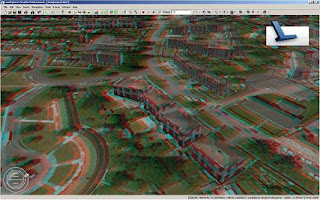
How to Create 3D Anaglyphs with Autodesk LandXplorer

3D Anaglyph created with Autodesk LandXplorer
In a previous post, I discussed the importance of visualization as part of the BIM process. I also provided several examples of visualization in action including this short 3D anaglyph video of a water treatment plant. Most of the videos referenced in my post though were pre-rendered with some of the animations requiring hours of computer processing power to create.

However, instead of pre-rendering your BIM models, another option is to create your 3D anaglyph in real time. This type of stereoscopic rendering is possible via the Stereo Mode option in
Autodesk LandXplorer. You can setup Stereo Mode for use with 3D anaglyph glasses (ie the type with the red/cyan lenses). Stereo Mode also supports 3D shutter glasses if your graphics hardware supports such functionality.

To enable Stereo Mode and create a 3D anaglyph, do one of the following:
  • Click the Tools menu and then select the Stereo Mode option
  • Use the keyboard shortcut: Ctrl+Shift+S
  • Enable Stereo from the Stereo Viewing toolbar
Note that you can adjust the setting for your eye distance in the edit field of the Stereo Viewing toolbar so that you can achieve results that generate the best 3D effect for you. The default value = 1.0.


So, grab your 3D glasses and hang on tight as you visualize your BIM models while flying through your cityscape in 3D with Autodesk LandXplorer.

Friday, July 23, 2010

Visualization and BIM: A Powerful Combination

Explore, validate and communicate model based designs before they’re real.

Proposed transportation networks, above and below ground infrastructure, neighborhood developments and other major municipal projects are often subjected to great scrutiny. Being able to use model based designs to generate high quality visualizations can help engineers, architects and others improve stakeholder communications, better convey design intent and expedite approvals.

As discussed in a previous
post, Building Information Modeling (BIM) is a process that leverages model based designs throughout the entire municipal lifecycle. Visualizations are an important part of that process. Accurate, photo realistic renderings, as well as, drive-through, fly-over and animated simulations can be used to explore design options clearly and accurately, validate designs and detect errors before construction.

For example, check out the Alaskan Way Viaduct
animation as released by the Washington State Department of Transportation. The video shows the drive-through experience after proposed changes to this major Seattle transportation corridor have been completed. In addition to communicating design intent, this type of visualization helps validate the design. Note proposed lane configurations, exit ramps, and tunnel lighting. Also, note the potential impact of buildings, signs, barriers and other visual obstructions on sightlines.

Visualizations are also useful in clash detection scenarios where the individual design elements of a BIM model are checked for interference with one another. Identifying and documenting clash related problems prior to construction can significantly reduce construction costs by reducing the number of RFIs and change orders during construction. For example, this
video posted by CivilFromTheGroundUp shows how clash detection can be used to identify the clash between an underground utility and the surface of a roadway.

Construction sequencing which is demonstrated in this
video is another useful type of visualization that aims to show how a design will be built over time and can be used to help coordinate multidiscipline construction projects.

Furthermore, BIM models can be used to create 3D visualizations to enhance the experience of a project before its real. With 3D movies such as “Avatar” and the release of 3D televisions, the importance of a 3D experience as it relates to design will undoubtedly increase. For example, check out this stereoscopic anaglyph animation of a water treatment facility. This video was created using
Autodesk 3DS Max by my colleague Louis Marcoux. You will of course need special glasses to view the 3D effect. Get the glasses with the red/cyan lenses.


In summary, visualizations and BIM are a powerful combination that can have a profound positive impact on your business:
  • Become more competitive
  • Win more RFPs
  • Identify the best design alternatives
  • Accurately convey design intent
  • Improve public and stakeholder communication
  • Reduce construction costs
  • Improve coordination of multidiscipline teams

Tuesday, June 1, 2010

BIM Expanded

This year, I will have had the pleasure of attending several conferences outside of my usual engineering and geospatial interests to include architecture and IT focused events such as:
What is especially compelling about these events is the opportunity for me to engage participants on the expanded definition of Building Information Modeling (BIM) beyond the traditional architectural focus. One example of this expanded definition for BIM is this article in Green Building Community by Terry Bennett which discusses BIM from a civil engineering perspective.

Another example is BIM for Sustainable Cities which combines model based design from architectural and engineering design perspectives to include the integrated processes that are built on coordinated, consistent information about the municipal developments, infrastructure and related assets.


A BIM for Sustainable Cities plan is part of a 3D digital cities initiative and depends on the convergence of CAD, GIS and BIM and the integration of…
  • Modeling and Design
  • Surveying & Data Collection
  • Planning, Site Selection & Conceptual Design
  • Clash Detection, Simulation and Analysis
  • Visualization
  • Multidiscipline Coordination
  • Construction & Construction Management
  • Operation and Maintenance
With a BIM for Sustainable Cities plan, municipalities are better able to:
  • Coordinate with architects, engineers, contractors and others
  • Better share digital design information, geospatial data, infrastructure models and other documentation among staff and project stakeholders
  • Use that information to accurately predict performance, appearance and cost
  • Reliably deliver municipal projects faster, more economically and with reduced environmental impact
  • Leverage model-based design information for operation and maintenance
BIM for Sustainable Cities embraces the entire municipal development lifecycle. This expanded view of BIM gives local governments, planners, engineers, architects, contractors and others an opportunity to take a more active role in neighborhood development and infrastructure projects that are planned, designed, built and managed in greener more sustainable ways.

Tuesday, February 10, 2009

3D GIS is Easy

Image courtesy of Dan Campbell, City of VancouverIf you thought 3D was hard, think again. Maybe a different point of view would help.

I recently had the pleasure of attending a seminar entitled “A New Dimension in GIS – 3D Analysis”, hosted by the British Columbia Chapter of URISA, in which a half-dozen speakers shared their 3D GIS experiences and insight during this one-day event.

Convergence: The opening keynote presentation by Doug Eberhard (Senior Director, Autodesk) set the tone of this event by providing us with an eye-popping vision of the future in which the convergence of design, geospatial analysis, simulation and visualization are fuelling the emerging business of digital cities. According to Eberhard, at the heart of digital cities are models. These models range from model agencies and model designers to model contractors and model operators. These models allow us to examine our world in new ways –ways that can help us become a model planet.

New Perspectives:
Dan Campbell (Manager, Graphics and Communications, City of Vancouver) discussed the City’s experiences, gathered over the last 20 years, in working with 3D models. In fact, it was Campbell that said, “3D is Easy; it’s 2D that’s hard.” His point was that we live in a 3D world and no-one needs to teach us how to interpret this 3D world. And yet, when we work with infrastructure designs, architectural plans and maps we force our 3D world into a 2D abstraction. According to Campbell, this 2D abstraction for the non-professional is equivalent to trying to read hieroglyphics - misinterpretation and lost meaning is often the result.

Integration: Dale Lutz (Vice President, Safe Software) explored the topic of integrating CAD, Building Information Modeling (BIM) and geospatial data and discussed the role of CityGML, Industry Foundation Classes (IFC) and LandXML in the creation of 3D models. Various integration scenarios were also presented including the use of 2D CAD buildings with LIDAR to create 3D extruded buildings and the use of 3D geo-referenced BIM.

Key Takeaway: For me, one of the key takeaways of this seminar was that 3D GIS is about making it easier for the users of the information and not the CAD and GIS gurus. It’s about an easier way to analyze, visualize and communicate information about our 3D world. The boundaries between design, visualization and geospatial analysis are blurring. And yet, it’s the people and processes and not the technology that remain obstacles in realizing the vision of 3D digital cities. Data integration and an open, non-proprietary approach continue to be at the heart of the solution.

Until next time...