Showing posts with label integration. Show all posts

Tuesday, December 14, 2010

CAD/GIS Integration Problems Persist

Whether it’s CAD or GIS, we all use a variety of tools to get the job done. One would think though that after more than 20 years, the task of integrating CAD and GIS data would no longer be a problem.

Imagine my surprise then when both of my
Unconference Sessions at Autodesk University (AU2010) were filled to capacity.

Each session began by exposing the magnitude of the CAD/GIS integration problem – a billion dollar problem that impacts engineers, contractors and suppliers throughout the planning, design and construction phases. However, these impacts pale in comparison to the many billions lost due to a lack of interoperability by the owner/operators during operation and maintenance phases (NIST).

Participants were then divided into small groups to discuss their own CAD/GIS integration problems. The results were interesting. Technology it seems was not the main point of discussion. In fact, organizational influences, data ownership, lack of understanding, workflow and standards were the primary factors contributing to an organization’s lack of data integration.


Next, participants were asked to come up with a list of possible solutions. Again, rather than “fix the technology”, discussions centered around solving data related issues and increasing communication, collaboration and education on the CAD/GIS integration topic.
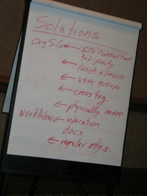


The session concluded by participants sharing their plan-of-action for tackling the issues exposed. In fact, when I asked participants, "Who is committed to tackling the CAD/GIS integration problem within their own organizations?", the vast majority raised their hands in a resounding yes!

If you were one of my session participants or are in the process of tackling your own CAD/GIS integration issues, please share your experiences by sending me a note or including a comment. I would love to hear about your progress.

For more session highlights, please check out
Spatial Sustain and Matt Ball's blog on this topic.

Thursday, November 25, 2010

CAD/GIS Integration and Autodesk LandXplorer at AU2010

Are you struggling with CAD/GIS data integration? Well, if enrollments for my two AU2010 workshops (see blog) on this topic are any indication, it seems that you’re not alone. Data integration is a hot topic!

In fact, when you throw
BIM and large-scale city and infrastructure models into the mix, the data integration issues can become overwhelming – especially if you don’t have the right plan or the right tools.

  • How do you get the big picture when you need to aggregate CAD and GIS data, wireframes and building models, surfaces and aerial photos?
  • How do you analyze and visualize this data in 3D quickly and efficiently?
If these questions resonate with you then check out
Autodesk LandXplorer. I’ve blogged about Autodesk LandXplorer previously. But why not register for an Autodesk LandXplorer class while at Autodesk University?

For example, Dan Campbell of the City of Vancouver is delivering a session (
CV220-3P) entitled “Claiming New Territory with Autodesk LandXplorer”. I’ve seen Dan Campbell present numerous times. His sessions are always informative, entertaining and filled with lots of eye-candy.

You also don’t want to miss the hands-on lab (
CV234-27) being led by Lynda Sharkey of Autodesk. Her lab is an introduction to Autodesk LandXplorer. Oh and be sure to check out the hilarious promo video for her class.

Thursday, November 18, 2010

CAD and GIS Integration Workshop at AU2010

If CAD and GIS data integration issues continue to plague your organization, if you’re frustrated by working with unstructured CAD files, if you’re perplexed by rigid GIS data models, if you’re looking for easy ways to add CAD data to your GIS databases, or if you're bewildered by the many obstacles to CAD/GIS integration then my CAD and GIS integration workshop may be for you.

This year, at
Autodesk University (AU2010), I am delighted to be facilitating two Unconference Sessions entitled, “The Billion Dollar Opportunity: A Workshop on CAD/GIS Integration”. These workshops are aimed at engineers, surveyors, architects, CAD and GIS professionals, and anyone interested in the CAD/GIS integration issue. Anticipated discussion topics will include:

  • Drivers for CAD/GIS integration
  • CAD/GIS integration scenarios
  • Approaches for addressing CAD/GIS integration issues
Note that these workshops fill quickly (the first one is already full). So, if you missed the opportunity to register for my first session (
Class ID: CV319-3U), try registering for my repeat session (Class ID: CV220-7U).

But don’t wait; I fully expect the second session to fill too.

See you at AU!

Friday, August 14, 2009

CAD and GIS Integration Workshop at AU2009

A new addition to Autodesk University (AU2009) is the Unconference Session where session content is created and driven by participants. Unconference Sessions represent an opportunity for you to engage with your peers around specific topics of interest. Lectures and formal presentations give way to open discussions where the sharing of ideas and experiences is encouraged.

This year, my colleague Neal Niemiec and I are delighted to be leading a 90-minute session entitled, “The Billion Dollar Opportunity: A Workshop on CAD/GIS Integration”. This workshop is aimed at engineers, surveyors, architects, CAD and GIS professionals, and anyone interested in the CAD/GIS integration issue. Anticipated discussion topics will include:

  • Drivers for CAD/GIS integration
  • CAD/GIS integration scenarios
  • Approaches for addressing CAD/GIS integration issues
The opportunity for open dialog during this workshop is exciting. So, if you have a specific issue that you want us to include on the agenda, please post a comment. If you’re going to be attending AU2009, be sure to register for our session (
Class ID: GS122-3) and come say “Hello”. We look forward to meeting you!

Wednesday, August 5, 2009

How to Keep both Water and Data Flowing with AutoCAD Map 3D

My colleagues Peter Southwood, Neal Niemiec and I recently had the pleasure of participating in a series of webcasts, hosted by DLT Solutions, Inc., on the topic of using AutoCAD Map 3D to improve data access, data confidence and utility of water and wastewater data. Descriptions and links to the archived webcasts appear below.

Analyzing your Water/Wastewater Data with AutoCAD Map 3D
Presenter: Michael Schlosser, Autodesk
AutoCAD Map 3D is a leading engineering platform for creating and managing your water/wastewater design information. However, AutoCAD Map 3D also has powerful querying and analysis capabilities that help you to examine your water/wastewater networks in new and useful ways. This presentation shows how queries, thematic mapping, buffers, and overlay analysis can be used to better leverage your water/wastewater data.
Recorded on July 29, 2009
Length: 50 min
Link to Webcast:
http://www.dlt.com/Analyze-Water-Archive

Improving Data Confidence with AutoCAD Map 3D for Water/Wastewater
Presenter: Neal Niemiec, Autodesk
Managing water and wastewater systems within budget and to agreed upon service levels requires reliable information about the network throughout the infrastructure lifecycle. However, this requirement is threatened by a lack of data standards which can negatively impact budgets, operations, and maintenance activities. AutoCAD Map 3D improves data confidence with industry specific attribute fields, symbology and classification templates. This presentation focuses on the water/wastewater utility toolkits for creating and maintaining data according to specified standards.
Recorded on July 14, 2009
Length: 41 min
Link to webcast:
www.dlt.com/autodesk/DataConfidence-Archive

Improving Access to your Water/Wastewater Data with AutoCAD Map 3D
Presenter: Peter Southwood, Autodesk
Access to current and accurate data about your water/wastewater network is crucial for sound decision making. AutoCAD Map 3D aggregates critical CAD, GIS and utility data for field, management and regulatory purposes. This presentation focus on how to improve data access and addresses connecting to data using Feature Data Objects (FDO), attaching to DWG files, importing/exporting foreign CAD/GIS data sources and creating PDF/DWF files.
Recorded on June 22, 2009
Length: 58 min
Link to webcast:
www.dlt.com/Improve-Access-Archive

Monday, March 16, 2009

The Obstacles to CAD/GIS Integration

In my last post, I discussed a need to address the issue of CAD/GIS integration during the design and data creation phases of a project rather than waiting until the data was ready to be moved into a corporate database. The responsibility to address this issue would rest with the creators of the data (ie the engineering and CAD professionals). The reason, I argued, was one of efficiency; that is, data that was properly structured during the front end of the data lifecycle would be easier to integrate throughout all downstream infrastructure related activities, thereby, saving time and collectively, billions of dollars.

So, why does the problem of CAD/GIS data integration continue to persist and negatively impact organizations? Why do so many continue to struggle with import/export workflows, work-arounds and the old way of doing things? Why does CAD/GIS integration remain an issue today?

Well, a number of reasons come to mind…

Data Issues: First there’s the data. Sometimes CAD/GIS data integration problems really are due to the differences in the data – differences such as the use of project coordinates versus geographic coordinates; the need for annotation (ie dimensions, callouts and other explanatory text) versus topology; the use of complex geometries (ie spline curves and 3D objects) versus the limitation of geospatial databases to store them. To a lesser extent, data formats can also be an obstacle as one attempts to massage the data from one format to another potentially introducing errors and redundancy in the process.

Organizational Structure: The way an organization is divided into its various departments and workgroups impacts communication and the flow of data throughout the organization. With respect to GIS, organizations have typically assigned GIS responsibilities and functions to the GIS Department or to a subgroup of the IT Department. This organization based separation of CAD and GIS, can create a communication gap between the data creators (ie the engineering and CAD professionals) and the maintainers of the geospatial data. Then the only time one group communicates with the other is when as-built information needs to be passed to the GIS folks for inclusion in the corporate database. Consequently, the GIS folks don’t understand the problems that can arise when attempting to use geospatial data in CAD and the CAD folks don’t understand the issues related to using CAD data in a GIS. In an attempt to overcome this communication gap between departments, organizations have held Corporate Demo Days, GIS Days and other events aimed at sharing and promoting departmental information, ideas and accomplishments.

Silo Syndrome: Organizational silos occur when departments seem to focus on their own needs without recognizing their impact on other departments or to the organization as a whole. For example, when communication between departments is poor, when the exchange of information is inefficient, or when job related requests are queued and delayed, individuals find ways to work around the problem. They begin to create copies of the data; they create their own databases; and they stop sharing information to help drive their own efficiency. Unfortunately, this can perpetuate the CAD/GIS integration gap and result in greater corporate inefficiencies. To help reduce departmental silos and ensure that both corporate and departmental needs are met, some organizations have embedded GIS responsibilities at both corporate and departmental levels.

Culture Clash: The very things that make us experts in our field also lead to differences in professional cultures. Whether it’s the contrast in educational and professional backgrounds, the knowledge and experience that we gain and share as a group, the jargon, or the type of projects we work on, they all lead to differences in the way we communicate and approach a task. These differences are often additional obstacles to CAD and GIS integration. For example, while a CAD professional is focused on documenting a design in such a way that it can be built to exact design specifications, a GIS professional may be more interested in how this information can be used for planning and analysis after construction. Culture clash seems to become most evident when people balk at the technologies used by others. What’s needed is a respect for both ends of the spectrum. It’s not about CAD or GIS; it’s really about embracing both.

Myths: Myths surrounding the capabilities of CAD continue to persist in spite of significant advances in this technology. Today’s CAD includes model-based design and rule-based workflows; integrates engineering designs with other CAD and GIS data; provides support for geographic coordinates, topologically structured features, spatial analysis and geospatial databases; and simplifies integration with web-based mapping. Rather than continuing to do things the old way because of an outdated view of CAD, current capabilities and new workflows should be examined for gains in efficiency and improvements in data integration.

Lack of Metrics: In the software industry, metrics are used to measure a wide variety of characteristics pertaining to a program’s performance. However, when it comes to the subject of CAD/GIS integration, few organizations monitor the amount of resources required, in terms of time or dollars, to move as-built information into a corporate database. The lack of metrics hides the inefficiencies and the corresponding costs associated with the CAD/GIS integration issue. So, integration challenges go unnoticed and opportunities for improved efficiency escape. Metrics are needed to highlight the CAD/GIS integration problem and to make a case for change.

Discipline Specific Tools: Discipline specific tools were created for a reason. For example, there’s nothing more powerful than the data creation and editing tools available in CAD for creating and documenting an engineering design. Similarly, GIS tools excel at spatial analysis. These discipline specific tools can perpetuate the CAD/GIS integration problem by isolating users from other ways of doing things. Users become accustomed to creating data without topology, storing their data in proprietary formats or using out-dated import/export workflows to facilitate data exchange. While some have attempted to re-create CAD-like functions as custom extensions to their GIS, others have embraced an Engineering GIS approach where CAD and GIS come together exploiting the advantages of both.

What’s In It for Me? Sometimes it just boils down to incentive. Perhaps Rod said it best: “Engineers as consultants or as in house departments are incented in such a way that they do not really care about the life cycle of the data... They just want to hammer out a design and their work stops.” In other words, significant advances in CAD/GIS integration might be made if the creators of the data are contractually obligated to create the data with a new end in mind. CAD standards have been in effect since the dawn of CAD. Perhaps it’s time for a new CAD standard - one that also addresses the downstream data requirements.


The above list represents those obstacles which I have encountered most often in my conversations with a variety of engineering, surveying, CAD and GIS professionals. I’m sure other obstacles exist. If you know of additional obstacles, if you have ideas for solving or eliminating them, if you have related experiences or comments, I would enjoy hearing from you…

Saturday, March 7, 2009

GIS Skills for the Engineering and CAD Professional

ENGIS: It's not Engineering or GIS; it's Engineering and GIS!
Last week I had the pleasure of visiting Calgary, Alberta and facilitating a half-day seminar aimed at demonstrating the crucial GIS skills needed by engineering and CAD professionals. This well attended seminar, hosted by Pacific Alliance Technologies, highlighted the differences between CAD and GIS workflows, reviewed the obstacles to CAD/GIS integration and discussed the importance of an Engineering GIS approach.

I was expecting the audience to consist mainly of engineering and CAD folks. So, I was surprised to discover that there was a 50:50 mix of both CAD and GIS professionals. It turned out that some of the geospatial participants were looking for a better understanding of CAD related workflows. They also wanted information on how to work and better communicate with their engineering and CAD counterparts so that they could potentially simplify their geospatial data integration tasks and drive productivity. Similarly, some of the engineering and CAD participants were seeking pointers on how to overcome resistance to GIS within their own engineering organizations.

So, why is there this resistance to GIS by some engineering firms?

Well, engineering is about design; it’s about creating documents that have the exact amount of detail necessary to construct what was designed and then ensuring that construction proceeds according to specification. To these firms, construction represents completion and so their design documents and as-built drawings reflect that.

However, according to the National Institute of Standards and Technology, the cost of inadequate interoperability for U.S. capital facilities during the operation and maintenance phases is estimated at $9 billion US. If you include infrastructure, like bridges and roads, then these costs sky-rocket even further!

Design documents and as-built drawings must be created with a new end in mind.

Engineering and CAD professionals must create their design documents in such a way that the embedded geospatial data can be utilized throughout the infrastructure lifecycle. Design data must be easily integrated with corporate databases so that this information can be used during infrastructure operation and maintenance activities. Engineering GIS can help.

As the original creators of our infrastructure data, I believe engineering and CAD professionals have a responsibility to ensure that this information can be easily integrated throughout the infrastructure lifecycle. To do otherwise, simply contributes to the billions of dollars already wasted due to the lack of interoperability and poor data integration.

Tuesday, February 10, 2009

3D GIS is Easy

Image courtesy of Dan Campbell, City of VancouverIf you thought 3D was hard, think again. Maybe a different point of view would help.

I recently had the pleasure of attending a seminar entitled “A New Dimension in GIS – 3D Analysis”, hosted by the British Columbia Chapter of URISA, in which a half-dozen speakers shared their 3D GIS experiences and insight during this one-day event.

Convergence: The opening keynote presentation by Doug Eberhard (Senior Director, Autodesk) set the tone of this event by providing us with an eye-popping vision of the future in which the convergence of design, geospatial analysis, simulation and visualization are fuelling the emerging business of digital cities. According to Eberhard, at the heart of digital cities are models. These models range from model agencies and model designers to model contractors and model operators. These models allow us to examine our world in new ways –ways that can help us become a model planet.

New Perspectives:
Dan Campbell (Manager, Graphics and Communications, City of Vancouver) discussed the City’s experiences, gathered over the last 20 years, in working with 3D models. In fact, it was Campbell that said, “3D is Easy; it’s 2D that’s hard.” His point was that we live in a 3D world and no-one needs to teach us how to interpret this 3D world. And yet, when we work with infrastructure designs, architectural plans and maps we force our 3D world into a 2D abstraction. According to Campbell, this 2D abstraction for the non-professional is equivalent to trying to read hieroglyphics - misinterpretation and lost meaning is often the result.

Integration: Dale Lutz (Vice President, Safe Software) explored the topic of integrating CAD, Building Information Modeling (BIM) and geospatial data and discussed the role of CityGML, Industry Foundation Classes (IFC) and LandXML in the creation of 3D models. Various integration scenarios were also presented including the use of 2D CAD buildings with LIDAR to create 3D extruded buildings and the use of 3D geo-referenced BIM.

Key Takeaway: For me, one of the key takeaways of this seminar was that 3D GIS is about making it easier for the users of the information and not the CAD and GIS gurus. It’s about an easier way to analyze, visualize and communicate information about our 3D world. The boundaries between design, visualization and geospatial analysis are blurring. And yet, it’s the people and processes and not the technology that remain obstacles in realizing the vision of 3D digital cities. Data integration and an open, non-proprietary approach continue to be at the heart of the solution.

Until next time...