Showing posts with label infrastructure. Show all posts

Tuesday, December 20, 2011

Debate Continues: BIM versus GIS

I recently had the pleasure of participating in a panel discussion entitled, “The Great BIM versus GIS Debate”. This 90-minute session in front of a packed room was moderated by Matt Ball (@SpatialSustain) and proved to be a lively (and sometimes heated) discussion between myself (@engis), Pete Southwood (@Geo_Pete) and members of the audience. Issues addressed in the debate encompassed technology; data accuracy, access, integration and analysis; collaboration and efficiency; and the future of GIS and BIM.

I introduced this debate during a previous blog post which you can find here. However, if you were unable to attend or simply want to review some of the highlights, I encourage you to check-out the following:

Dale Lutz (@DaleAtSafe) posted his thoughts on the debate here. Although there was no clear knock-out punch by either opponent, he did include a list of the best (and some would say hilarious) “zingers”.

Matt Ball (@SpatialSustain) posted his thoughtful perspectives of the debate here. His great summary covers “Concepts or Tools”, “Point of Truth” and “Integrated Infrastructure Information”.

I’ve also posted a replay of “The Great BIM versus GIS Debate” to YouTube. For those of you wanting to review the debate in its entirety, I’ve made a recording of the complete 90-minute session which I divided into chapters which you can access via the links below:
Session Introduction and Overview (3:37)
The BIM Perspective (5:42)
The GIS Perspective (9:09)
Who are the BIM and GIS Users? (Part 1: Panel Responds) (5:05)
Who are the BIM and GIS Users? (Part 2: Audience Responds) (3:24)
Who are the BIM and GIS Users? (Part 3: Audience Responds) (12:40)
What are potential accuracy issues? (8:19)
What is the role of modeling/analysis? (Part 1: Panel Responds) (6:36)
What is the role of modeling/analysis? (Part 2: Audience Responds) (11:34)
What is the role of modeling/analysis? (Part 3: Audience Responds) (14:49)
Collaboration, integration and the future of BIM & GIS (7:09)

Monday, November 28, 2011

The Great BIM versus GIS Debate

Are you a GIS professional convinced that GIS is the technology of choice for mapping and analyzing the world we live in?

Are you an engineer or architect with years of CAD experience confident in your abilities to create cost effective and sustainable designs?

Regardless of which camp (GIS or CAD) that you may be a part of, “The Great BIM versus GIS Debate” is sure to be a lively session at Autodesk University this year.

GIS gives us a way of mapping, analyzing and managing our real world assets within a geospatial context. It gives us a way of integrating and relating seemingly disparate data sets based on geography. GIS is a tremendously useful planning tool that helps provide us with insight into our infrastructure projects in a way that traditional CAD technology cannot.

BIM is similar to GIS in some ways. If you are unfamiliar with BIM as it applies to infrastructure then I encourage you to check out a detailed explanation in my previous blog post. Simply put, BIM is Information Modeling for the Built environment. It’s is a process - not software - a process that lets you explore the physical and functional characteristics of your project digitally, before it’s built. At the heart of BIM is an information model – a model that is used throughout the infrastructure lifecycle – a model that is passed from planning and conceptual design phases to detailed design, construction and then to management phases. As a result, the application of the BIM process can lead to significant time and dollar savings during construction and additional savings throughout the life of the asset as a result of better more sustainable designs.

So, when it comes to supporting the infrastructure lifecycle, which is better? BIM or GIS. Both BIM and GIS have their advantages; both have their supporters.

Well, if you’re unsure about BIM as it applies to GIS or visa-versa, then I encourage you to check out the “The Great BIM versus GIS Debate” at Autodesk University. This panel session will be moderated by Matt Ball (@SpatialSustain). Peter Southwood (@Geo_Pete) and I (@engis) will be opposing each other on behalf of the two camps: GIS and BIM. With what I am sure will be provocative questions from Matt Ball and audience members, Peter and I will feel the heat as we do our best to respond to questions encompassing technology; data accuracy, access, integration and analysis; collaboration and efficiency; and the future of GIS and BIM.

If you are attending Autodesk University, please join us.


Wednesday, February 3, 2010

How to Unlock the Data in your CAD Drawings

Are you using AutoCAD to help plan and manage your infrastructure network? Are you wondering how you can access and better use the information in your AutoCAD drawings? Do you want to be able to analyze your AutoCAD drawings, generate material lists and reports, or reveal new patterns in the data? If so, there is a way with AutoCAD Map 3D – the better AutoCAD for working with your infrastructure data.

With AutoCAD Map 3D you can query your AutoCAD drawings in much the same way that a spreadsheet or database can be queried. For example, with AutoCAD Map 3D, you can query by CAD properties such as color and layer, as well as, by location.

Consider a scenario in which a water utility or municipality is reviewing their watermain replacement program. Cast iron watermains are considered a priority. The AutoCAD drawing containing information about the watermain network must be analyzed to determine the location of the cast iron watermains, as well as, their corresponding lengths and diameters.

To see how this type of analysis can be done, please review the following short video which demonstrates the use of CAD queries in AutoCAD Map 3D.

Tuesday, January 5, 2010

Webcast: Resolving the Municipal and Utility As-built Backlog

Last month, I had the privilege of delivering a webcast entitled “Resolving the Municipal and Utility As-Built Backlog”. The webcast was hosted by IMAGINiT Technologies and was aimed at local, state/provincial and federal governments; utilities; public works and infrastructure management professionals; as well as, engineering, CAD and GIS professionals.

Note that I have
blogged about the as-built problem previously and this webcast served to expand on the topic. However, the webcast also confirmed that as-built backlogs remain an issue for many organizations. In fact, 69% of webcast participants indicated that they continue to have an as-built problem.


Furthermore, over 50% of participants indicated that the as-built backlog was a reason for concern and more than 10% indicated that their as-built backlog was unmanageable.


The webcast continued with a description of a typical as-built workflow and a discussion of the three main causes of the as-built backlog. A strategy for resolving the as-built backlog and improving data currency was presented and demonstrations were used to highlight resulting benefits.

If your as-built drawings are months or years out-of-date and you’re looking for ways of improving the currency of your infrastructure databases, please check out the archived webcast here.

Tuesday, August 25, 2009

Beyond PSAB 3150

Effective asset data management requires more detail than generally required for regulatory compliancy. However, standards such as Section 3150 of the Public Sector Accounting Board (PSAB 3150) can serve as a catalyst for changes in the way that municipalities approach their infrastructure asset data. For example, in a previous post on this subject, I discussed the impact of the as-built backlog on the accuracy of PSAB 3150 reporting. My article, Streamlining Infrastructure Asset Management which was published in the August issue of Government Purchasing, continues discussion on this subject by looking beyond PSAB 3150. The article explores how Autodesk Topobase can support these new accounting standards and highlights examples from the City of Lloydminster, SK; Strathcona County, AB and Las Vegas, NV. Please be sure to check out my article on page 28 in the digital edition of the publication.

Monday, March 30, 2009

GIS Databases Negatively Impacted by As-Built Problem

I just returned from Dallas, Texas this week where I delivered a seminar discussing data to design workflows and CAD/GIS integration. During the seminar, which was hosted by Expert Computing Solutions, an interesting discussion on the topic of the as-built backlog arose. Recall from one of my previous posts that the as-built backlog refers to the delay between when infrastructure has been constructed and when information about this construction is entered into GIS and records databases. According to seminar participants, that delay ranges anywhere from a few months to several years. Some participants revealed an indefinite delay; in other words, their databases were never up-to-date!

So, what are the problems of such a delay? What are the consequences of not having an up-to-date GIS database? Well, the impacts are many; listed below are just a few…

Poor decision making: Out-of-date information about the type, location and other related attributes about the above and below ground infrastructure can lead to inaccuracies in predicating future repair and maintenance requirements which can lead to decreased infrastructure life expectancy and premature replacement.

Decreased efficiency: When work orders are based on out-of-date databases, field activities are impacted; for example, when crews are dispatched in response to a repair or routine maintenance request only to find that upon arriving at the field location that they have the wrong equipment, crews must make a trip back to the warehouse to retrieve the correct piece of equipment. The result is an inefficient use of resources with time, dollars and fuel all wasted.

Re-work: Re-work occurs when the information in the GIS database must continually be verified against paper as-built drawings simply because this as-built information had not been loaded into the database yet.

Data confidence: When users know that the corporate database is not current, confidence in the data can be eroded to the point where users stop relying on the corporate database in favor of their own records. The result is data redundancy and all its corresponding problems.

Insufficient budgets: When infrastructure budgets are derived from out-of-date databases, a budget shortfall becomes a real possibility, especially in areas of rapid growth.

Environment and public safety issues: Worse yet, when users trust out-of-date information, bad decisions can be made – decisions which can harm the environment, impact public safety and create liability exposure. For example, according to the National Post, trusting old design drawings proved to be a costly mistake, when a contractor ruptured a crude oil pipeline in Burnaby, BC almost two years ago. The result was a toxic geyser that spewed almost a quarter of a million litres of crude oil onto residences, streets and into the Pacific Ocean.

Inaccurate regulatory reports: The accuracy of reports on capital assets in response to regulatory requirements such as
PSAB 3150 and GASB 34 becomes suspect when based on GIS databases that are suppose to have a current inventory of above and below ground infrastructure but instead are potentially years out-of-date.

I’m sure the as-built problem generates additional consequences. However, given the above, can corporate GIS databases that are months or years out-of-date really be trusted? Caution is prudent.

If you know of other as-built related issues or have related comments, I would enjoy hearing from you…

Saturday, March 7, 2009

GIS Skills for the Engineering and CAD Professional

ENGIS: It's not Engineering or GIS; it's Engineering and GIS!
Last week I had the pleasure of visiting Calgary, Alberta and facilitating a half-day seminar aimed at demonstrating the crucial GIS skills needed by engineering and CAD professionals. This well attended seminar, hosted by Pacific Alliance Technologies, highlighted the differences between CAD and GIS workflows, reviewed the obstacles to CAD/GIS integration and discussed the importance of an Engineering GIS approach.

I was expecting the audience to consist mainly of engineering and CAD folks. So, I was surprised to discover that there was a 50:50 mix of both CAD and GIS professionals. It turned out that some of the geospatial participants were looking for a better understanding of CAD related workflows. They also wanted information on how to work and better communicate with their engineering and CAD counterparts so that they could potentially simplify their geospatial data integration tasks and drive productivity. Similarly, some of the engineering and CAD participants were seeking pointers on how to overcome resistance to GIS within their own engineering organizations.

So, why is there this resistance to GIS by some engineering firms?

Well, engineering is about design; it’s about creating documents that have the exact amount of detail necessary to construct what was designed and then ensuring that construction proceeds according to specification. To these firms, construction represents completion and so their design documents and as-built drawings reflect that.

However, according to the National Institute of Standards and Technology, the cost of inadequate interoperability for U.S. capital facilities during the operation and maintenance phases is estimated at $9 billion US. If you include infrastructure, like bridges and roads, then these costs sky-rocket even further!

Design documents and as-built drawings must be created with a new end in mind.

Engineering and CAD professionals must create their design documents in such a way that the embedded geospatial data can be utilized throughout the infrastructure lifecycle. Design data must be easily integrated with corporate databases so that this information can be used during infrastructure operation and maintenance activities. Engineering GIS can help.

As the original creators of our infrastructure data, I believe engineering and CAD professionals have a responsibility to ensure that this information can be easily integrated throughout the infrastructure lifecycle. To do otherwise, simply contributes to the billions of dollars already wasted due to the lack of interoperability and poor data integration.

Friday, February 20, 2009

As-built Backlogs Impact Accuracy of PSAB 3150 Reports

As of January 2009, Section 3150 of the Public Sector Accounting Board (PSAB 3150) requires Canadian municipalities to report on their tangible capital assets including roads, bridges, utilities, water systems, sewer networks and land. The accuracy of such a report is based, in part, on the currency of a municipality’s infrastructure inventory databases. However, these databases are often out-of-date due to the as-built backlog.

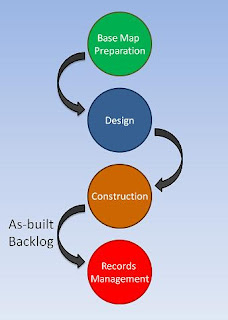
The as-built backlog refers to the delay experienced between when infrastructure has been constructed and when information about this construction is entered into the records database. These delays often span months and sometimes years and make it difficult to provide reliable information about the infrastructure for field, management and regulatory requirements such as PSAB 3150.

The as-built backlog refers to the time needed to add construction data to the records database after construction is completeThe as-built workflow can be explained with an example. A new subdivision project typically starts by assembling a collection of cadastral maps, existing infrastructure data and other information from a variety of sources to create a base map. Subdivision design is next; new infrastructure is drafted, existing infrastructure is updated and detailed design drawings for construction are created. Then construction takes place and upon completion, information about the construction is collected and compared to the design documents to create an as-built drawing. This as-built information is then used to update the infrastructure inventory database.

The as-built problem arises for several reasons:

  • Accelerated development during booming economies often means that engineering and construction firms have all-hands-on-deck to keep up with construction demand. Consequently, creating as-built drawings is sometimes just not a priority.
  • As-built drawings are often created from paper design documents that contain redline markups describing the as-constructed information. These paper documents are then re-drafted to create an electronic version that is added to the infrastructure inventory database. The re-drafting effort is error prone and time consuming.
  • As-built drawings and the infrastructure inventory database are often maintained via different systems (typically CAD and GIS) and by different departments. Loading CAD data into a records database may require translation, editing for topology and other inefficient workflows.
As you can see, workflow contributes to the as-built backlog which impacts the currency of the infrastructure database and inadequate currency impacts the accuracy of PSAB 3150 reporting. If your infrastructure database is months or years out-of-date then how can you be sure that your PSAB 3150 reports on tangible capital assets are accurate?

The solution requires a new way of thinking. Stay tuned as I discuss proposed solutions to the as-built problem in future posts.

Until next time…

Monday, January 19, 2009

The Five Principles of Engineering GIS

Have you ever rummaged through your toolbox looking for that certain tool only to find that you stored it somewhere else? If you have then you know how frustrating and inefficient it can be.

Well, when it comes to CAD and GIS, traditional thinking separates design tools from geospatial tools into different packages. When you’re faced with working in both domains, however, you end up switching back and forth between those packages. This means you also need to pass the data back and forth. The process is error prone and not very efficient.

Engineering GIS combines CAD and GIS capabilities into a single unified toolset. That is, the engineering design, data creation and editing tools of CAD are combined with the database, analysis and spatial data management tools of GIS.

There are five key principles of Engineering GIS:

1. Data passes through a lifecycle. Engineering GIS recognizes that data passes through a lifecycle. For example, when working in the municipal infrastructure domain, data moves through various phases from surveying and mapping, to design and construction, and finally to management. Engineering GIS assumes that the design information will be used in different ways by many people downstream from the engineering design process. Consequently, engineering drawings are topologically correct and “GIS ready” which streamlines the task of incorporating this information into an infrastructure management system and a geospatial database.

2. Access data natively. Engineering GIS recognizes that data comes in many different formats and from many different sources including traditional engineering and GIS environments, spreadsheets and databases, as well as, desktop and web-based sources. However, rather than relying on a data import/export process, Engineering GIS promotes working with the data in its native format. Consequently, data integrity is maintained, data redundancy is reduced and efficiency is improved.

3. Leverage design tools. Engineering GIS leverages CAD and engineering design tools because of their precision and ease of use for data creation and maintenance of engineering design features, as well as, mapping and other geospatial data.

4. Leverage geospatial tools. Engineering GIS leverages GIS tools because of their data oriented capabilities for automated mapping, spatial analysis and management of geospatial databases.

5. Renderings must be accurate. Whether printed to paper or published to the Web, Engineering GIS ensures that drawings and maps are accurately rendered with the point, line and polygon styles, raster and vector overlays, symbology, dimensioning and overall appearance that users expect.


As you can see, with Engineering GIS, you don’t have to choose between CAD and GIS software because both types of tools are available in one place. Together, they create a toolset that simplifies engineering and geospatial data integration.

Until next time...why not take a moment to geoExpress yourself?

Wednesday, January 14, 2009

CAD and GIS like Milk and Cookies

Milk and cookies - just plain good! There’s something about pairing the crunchy sweetness of cookies with a refreshing glass of milk that not only tastes great but satisfies too. Some things are meant to be together.

I think that CAD and GIS are kind of like that; I think CAD and GIS are meant to be together.

If you are an engineer or a drafting professional, you know all about CAD. You know the value of using CAD for engineering design and drafting; you know that when it comes to producing accurate drawings for construction purposes, CAD is the right tool for the job. In fact, there’s no better tool.

However, as an engineer, you may also have a need to place your designs within a geospatial context; you may need to combine design information with geographic data and you may need to examine your designs using spatial analysis techniques. In fact, attribute data, raster imagery and thematic mapping may help you to better design and visualize your infrastructure projects.

Traditional thinking separates design workflows from geospatial workflows. Consequently, you stick to what you know. With little experience in GIS or little time to learn new technologies, a choice is made; you focus on design and let someone else handle the geospatial stuff.

Unfortunately, this approach results in a disconnect between design departments and GIS departments, and between CAD data and GIS data. Consequently, workflows suffer which compromise efficiency, affect decision making, and impact data accuracy and currency.

However, there is an alternative: a unified approach called Engineering GIS that embraces both engineering design and GIS. Engineering GIS together with an improved understanding of how GIS skills can complement existing design skills can help overcome those workflow challenges and ensure that CAD and geospatial data are integrated in a manner that respects both engineering design and GIS requirements.

CAD and GIS like milk and cookies – just plain good.

Stay tuned as I elaborate on the importance of an Engineering GIS approach in future posts. I’ll also highlight some of the challenges encountered when attempting to integrate design information with geospatial data and I’ll review the key skills that you need in order to take advantage of Engineering GIS.

Until then… remember to geoExpress yourself.

Wednesday, January 7, 2009

The Road Ahead: Time for Change

Happy New Year and welcome to geoExpressions!

For many people, now is the time to think of the road ahead – the time for making New Year’s resolutions. Yet, while some people vow to get more exercise, strive to lose weight or promise to quit smoking, I committed to writing a blog. Ok – I have to admit; even though I have written and published several papers and presented numerous conference presentations about CAD and GIS throughout my career, geoExpressions is my first blog and this blog entry is my first post.

As an engineer who has worked in the GIS industry since 1988, I have witnessed the evolution of design drafting from pencil and paper to computer aided drafting to model based design. I have seen CAD evolve from a drawing only environment to one that embraces geospatial data and databases. Today’s CAD has changed.

And yet, I still see many engineering, CAD and geospatial professionals continue to limit CAD to the realm of design drafting. Consequently, for many organizations, paper is still the prevalent output medium for maps and drawings; integration of CAD and GIS data means an inefficient import/export process; and analysis involves loading the data into spreadsheets or handing the data over to geospatial gurus. Ultimately, these outdated workflows result in decreased efficiencies which negatively impact budgets and business objectives.

As local governments, utilities and other organizations design, build and manage our above- and below-ground infrastructure in the face of ever increasing infrastructure deficits, it is imperative that we find new ways of doing things. The more dollars we save; the more dollars we can put towards repairing our roads, bridges, water mains and other infrastructure.

For my New Year’s resolution, I have committed to writing this blog because of a need for change... a more efficient way of expressing my thoughts on the engineering and geospatial challenges still encountered by many organizations.

And so, when you look at the road ahead, if you are frustrated by CAD and GIS integration, if you are looking to put more dollars towards maintaining the roads rather than on outdated and inefficient workflows, make a New Year’s resolution; challenge the status quo and commit to new ways of doing things.

Until next time... go ahead... take a moment to geoExpress yourself!